


Key numbers
- 1 knot = 1.15078 mph = 1.852 km/h exactly (one nautical mile per hour)
- GPS shows speed over ground (SOG); a paddlewheel shows speed through water (STW). The gap is the current.
- Hull speed of a displacement boat ≈ 1.34 × √(waterline in feet) knots: a 30 ft waterline gives 7.3 kn (8.5 mph)
- Vessels 65 ft (19.8 m) and longer must keep to 10 knots over ground in NOAA right whale zones in season
- Phones are typically accurate to 4.9 m (16 ft) under open sky, per GPS.gov
On this page
- How to use the Boat Speedometer
- How does a GPS boat speedometer work?
- What is the difference between SOG and STW on a boat?
- How fast do boats go in knots and mph?
- Is 20, 30, 40 or 50 knots fast for a boat?
- How fast is no-wake speed, and what are the boat speed limits in the US?
- How accurate is a phone as a boat speedometer?
- How do you use this boat speedometer?
- Should a boat speedometer show knots or mph?
- Is speed a factor in boating accidents?
- Frequently asked questions
How to use the Boat Speedometer
- 1Get a clear view of the skyStay on deck or near a window; switch the unit to knots for marine speed.
- 2Tap Start and allow locationYour browser asks for location permission once. The first GPS fix usually arrives in 5–30 seconds.
- 3Pick your unitChoose km/h, mph, knots or m/s. Your choice is remembered on this device.
- 4Read speed, max, average and distanceThe gauge and digital readout update about once a second. Distance and average count only while you are moving.
- 5Stop or resetTap Stop to pause, Reset to clear the trip. Nothing is stored or sent anywhere.
Works in any modern phone browser. Back to the speedometer ↑
How does a GPS boat speedometer work?
A GPS boat speedometer reads the speed your phone’s satellite receiver calculates from the Doppler shift of GPS signals, then shows it in knots: that number is your true speed across the Earth’s surface, called speed over ground (SOG). The gauge above is set up for the water: it starts in knots, runs from 0 to 60 kn, and tracks top speed, average speed and trip distance while the page is open.
Under the hood there is no paddlewheel, no transducer and nothing to mount through the hull. Your browser asks the phone for its position through the W3C Geolocation API. The phone’s GNSS chip (GPS plus, on most modern phones, Galileo, GLONASS and BeiDou) returns a position and a speed value, which the W3C specification defines as the horizontal speed in meters per second. The page converts it with exact factors (1 knot = 1,852 meters per hour, so 1 m/s = 1.943844 knots), smooths the jitter, and draws the needle. Nothing is uploaded: the calculation stays on your phone.
Because the speed comes from satellites, a boat speedometer app is equally happy on a kayak, a pontoon on a lake, a center-console offshore, a sailboat or a ferry deck. It does not care how the boat is pushed; it only measures how fast you move over the bottom.
Definitions used on this page. Knot (kn or kt): one nautical mile per hour, 1.15078 mph. Nautical mile (NM): exactly 1,852 m (6,076 ft), about one minute of latitude. SOG (speed over ground): speed relative to the seabed or lake bottom, what GPS measures. STW (speed through water): speed relative to the surrounding water, what a paddlewheel or pitot speedometer measures. Hull speed: the speed at which a displacement hull’s bow wave is as long as its waterline. Steerageway: the minimum speed at which the rudder still steers the boat. No-wake zone: an area where boats must go slow enough not to throw a wake.
If your phone shows nothing at first, wait: a cold GPS fix on open water usually takes 10 to 60 seconds, faster if you opened the page at the dock with cell signal. For the same speedometer in a car or on foot, use the online speedometer on the home page.
What is the difference between SOG and STW on a boat?
SOG (speed over ground) is how fast you cross the bottom; STW (speed through water) is how fast you move through the water around you. The difference is the current: SOG = STW + current when the current is behind you, and STW − current when it is on the nose. A GPS boat speedometer always shows SOG.
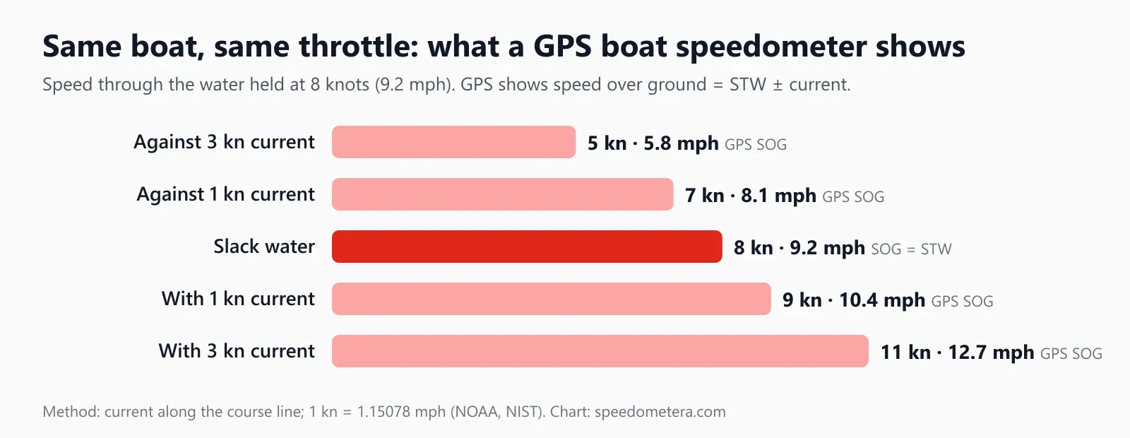
This single distinction explains most “my GPS is wrong” complaints from boaters. Imagine you hold the throttle so the boat moves at 8 knots through the water. In slack water both instruments say 8. Push against a 2-knot ebb and the paddlewheel still says 8, but GPS drops to 6, because the water itself is carrying you backward at 2 knots. Turn around and GPS jumps to 10. NOAA reports tidal and river currents in knots for exactly this reason: they add to or subtract from a vessel’s speed directly. NOAA’s National Data Buoy Center uses the same framing in its sea state guide, describing a ship “heading at 15 knots aided by a tide or current of three knots.”
Here is the full set for a boat at 8 knots STW with the current running directly along your course:
| Current along your course (knots) | Speed through water, STW (knots) | GPS speed over ground, SOG (knots) | SOG (mph) | Time for 10 nautical miles |
|---|---|---|---|---|
| 3 kn against | 8 kn | 5 kn | 5.8 mph | 2 h 00 min |
| 2 kn against | 8 kn | 6 kn | 6.9 mph | 1 h 40 min |
| 1 kn against | 8 kn | 7 kn | 8.1 mph | 1 h 26 min |
| Slack water | 8 kn | 8 kn | 9.2 mph | 1 h 15 min |
| 1 kn with you | 8 kn | 9 kn | 10.4 mph | 1 h 07 min |
| 2 kn with you | 8 kn | 10 kn | 11.5 mph | 1 h 00 min |
| 3 kn with you | 8 kn | 11 kn | 12.7 mph | 0 h 55 min |
The last column shows why it matters. For the same fuel burn, a 10-nautical-mile run takes 2 hours against a 3-knot current but only 55 minutes with it, more than twice as long. That is why sailors time inlets and passes to the tide, and why your ETA should be based on SOG, not STW.
When does each number matter?
- Use SOG (GPS) for ETAs, fuel range over a distance, posted speed-limit zones measured over the bottom, logging a trip, and checking a whale-zone speed rule (the federal rule is written as “10 knots or less over ground”).
- Use STW (paddlewheel or pitot) for engine and propeller tuning, sail trim, true-wind calculations and comparing runs in different currents.
- Use the difference to estimate the current: if the paddlewheel says 8 and GPS says 6.5 on a steady heading, roughly 1.5 knots of water is against you. Run the same leg in both directions; the average of the two GPS readings approximates your speed through the water.
Crosscurrents are a little more complex: a current from the side mostly pushes you off course rather than changing your speed, and the GPS heading (course over ground) then differs from the compass heading. Our compass shows which way the bow points, so you can compare the two.
How fast do boats go in knots and mph?
A displacement boat (sailboat, trawler, canoe) is limited by its waterline to roughly 1.34 × √(waterline in feet) knots, about 5 to 10 knots for most recreational hulls. Planing powerboats climb on top of their bow wave and can run several times faster, commonly 20 to 40 knots (23 to 46 mph) at cruise and wide-open throttle. Your GPS reading tells you which regime you are in.
The hull speed formula comes from wave physics. A boat moving through the water makes a bow wave, and a deep-water wave of length L travels at √(g·L / 2π). When the boat reaches the speed of a wave as long as its own waterline, the hull sits in a trough between its bow and stern waves and has to climb uphill to go faster. Work the number through with standard gravity (9.80665 m/s²) and the waterline in feet, and the constant comes out at 1.3407 knots per √ft (2.43 knots per √m). That is the famous “1.34.”
Hull speed (knots) ≈ 1.34 × √(waterline length in feet)
| Waterline length (ft) | Waterline length (m) | Hull speed (knots) | Hull speed (mph) | Hull speed (km/h) |
|---|---|---|---|---|
| 12 ft | 3.7 m | 4.6 kn | 5.3 mph | 8.6 km/h |
| 16 ft | 4.9 m | 5.4 kn | 6.2 mph | 9.9 km/h |
| 20 ft | 6.1 m | 6.0 kn | 6.9 mph | 11.1 km/h |
| 25 ft | 7.6 m | 6.7 kn | 7.7 mph | 12.4 km/h |
| 30 ft | 9.1 m | 7.3 kn | 8.5 mph | 13.6 km/h |
| 35 ft | 10.7 m | 7.9 kn | 9.1 mph | 14.7 km/h |
| 40 ft | 12.2 m | 8.5 kn | 9.8 mph | 15.7 km/h |
| 50 ft | 15.2 m | 9.5 kn | 10.9 mph | 17.6 km/h |
| 60 ft | 18.3 m | 10.4 kn | 12.0 mph | 19.2 km/h |
Treat the table as a guide, not a speed limit. Waterline length grows as a boat heels or squats, light and narrow hulls (racing dinghies, multihulls, rowing shells) beat the formula, and a following sea or a favorable current adds speed over ground that the formula ignores. The table is useful for a reality check: if your 30-foot-waterline cruising sailboat shows 9 knots on GPS in flat water, look for a fair current before you celebrate.
Planing hulls work differently. Once enough power pushes the boat up onto the surface, it skims rather than displaces, and speed depends on horsepower, weight, hull shape, propeller pitch and load. That is why two “21-foot” boats can differ by 20 knots at full throttle. A GPS boat speedometer is the simplest honest way to find your own numbers: run at a fixed RPM in both directions on calm water, average the two readings to cancel any current, and note the result. Repeat at several RPMs and you have a speed curve for your boat. If you also note the fuel flow, the speed, distance and time calculator turns it into range and trip time.
For quick orientation, this is what common boating speeds mean in mph and in time on the water:
| Speed (knots) | mph | km/h | Minutes per nautical mile | Time for 10 nautical miles |
|---|---|---|---|---|
| 3 kn | 3.5 mph | 5.6 km/h | 20.0 min | 3 h 20 min |
| 5 kn | 5.8 mph | 9.3 km/h | 12.0 min | 2 h 00 min |
| 6 kn | 6.9 mph | 11.1 km/h | 10.0 min | 1 h 40 min |
| 8 kn | 9.2 mph | 14.8 km/h | 7.5 min | 1 h 15 min |
| 10 kn | 11.5 mph | 18.5 km/h | 6.0 min | 1 h 00 min |
| 15 kn | 17.3 mph | 27.8 km/h | 4.0 min | 40 min |
| 20 kn | 23.0 mph | 37.0 km/h | 3.0 min | 30 min |
| 25 kn | 28.8 mph | 46.3 km/h | 2.4 min | 24 min |
| 30 kn | 34.5 mph | 55.6 km/h | 2.0 min | 20 min |
| 35 kn | 40.3 mph | 64.8 km/h | 1.7 min | 17 min |
| 40 kn | 46.0 mph | 74.1 km/h | 1.5 min | 15 min |
| 50 kn | 57.5 mph | 92.6 km/h | 1.2 min | 12 min |
| 60 kn | 69.0 mph | 111.1 km/h | 1.0 min | 10 min |
The “minutes per nautical mile” column is the boater’s version of a running pace: divide 60 by your speed in knots. At 6 knots each nautical mile takes 10 minutes, which makes ETAs easy to do in your head with a chart. For any other value, use the knots to mph converter or go the other way with mph to knots.
Is 20, 30, 40 or 50 knots fast for a boat?
It depends on the hull. For a sailboat or any displacement hull, 10 knots is already fast; for a planing powerboat, 20 to 30 knots is a normal cruise, 40 knots is fast and 50 knots is race-boat territory. For ships, the hull speed formula sets the scale: a displacement hull needs about 223 ft of waterline to reach 20 knots and about 406 ft to reach 27 knots.
| Speed (knots) | mph | km/h | Is it fast? |
|---|---|---|---|
| 10 kn | 11.5 mph | 18.5 km/h | Fast for a displacement boat: hull speed of a 56 ft waterline. Also the federal 10-knot limit for vessels 65 ft and longer in North Atlantic right whale zones |
| 15 kn | 17.3 mph | 27.8 km/h | A normal passage speed for a ship; NOAA’s sea-state guide uses a ship at 15 knots as its example |
| 20 kn | 23.0 mph | 37.0 km/h | Quick for a ship (about 223 ft of waterline at hull speed); an easy cruise for a planing powerboat |
| 21 kn | 24.2 mph | 38.9 km/h | For a displacement ship, hull speed needs about 246 ft of waterline, so 21 knots is brisk |
| 25 kn | 28.8 mph | 46.3 km/h | A brisk planing cruise for a runabout or center console |
| 27 kn | 31.1 mph | 50.0 km/h | For a ship, about 406 ft of waterline at hull speed: fast for anything that cannot plane |
| 30 kn | 34.5 mph | 55.6 km/h | Fast cruise for most recreational powerboats |
| 40 kn | 46.0 mph | 74.1 km/h | Fast: the top of the common 20 to 40 knot planing range |
| 50 kn | 57.5 mph | 92.6 km/h | Very fast: performance and race boats; as a wind, storm force (48 to 55 knots) |
The waterline figures come from the hull speed formula above, solved for length: waterline (ft) = (knots ÷ 1.34)². Large ships with long, fine hulls and bulbous bows can run close to or above that number, so treat it as a scale, not a limit. A 40 mph boat is doing 34.8 knots, quick for any recreational boat. Wind uses the same unit: on the National Weather Service Beaufort scale 34 to 40 knots is a gale, so a 40-knot forecast is no day for a small boat. And 20 knots is faster than 20 mph: it is 23.0 mph (see knots to mph).
How fast is no-wake speed, and what are the boat speed limits in the US?
There is no single US boat speed limit. Most no-wake rules set no number at all: they require the slowest speed that still lets you steer, which for small craft is typically only a few knots. Numeric limits, where posted, are local, and federal law adds a “safe speed” duty plus a 10-knot rule for large vessels in right whale zones.
The rules stack in layers, and a boat speedometer helps you follow each one:
| Rule | Who sets it | What it says | Speed measured as |
|---|---|---|---|
| Safe speed (Rule 6) | US Coast Guard, 33 CFR 83.06 | Every vessel must go at a speed that lets it avoid collision and stop in a distance suited to conditions | No number; depends on visibility, traffic, wind, current, depth |
| Idle Speed No Wake | Florida, F.A.C. 68D-23.103 | No faster than needed to maintain steerageway and headway | No number |
| Slow Speed Minimum Wake | Florida, F.A.C. 68D-23.103 | Fully off plane and settled in the water, with no excessive wake | No number |
| Posted numeric zone (e.g. “25 MPH”) | Florida, F.A.C. 68D-23.103 | Posted number is the maximum in the marked area | Statute mph over the bottom (GPS-style SOG) |
| Slow-no-wake within 100 ft | Delaware, 7 Del. Admin. Code 3100-6.0 | Slow-no-wake within 100 ft (30.5 m) of docks, floats, ramps, swim areas, swimmers and anchored, moored or drifting vessels | No number |
| Right whale Seasonal Management Areas | NOAA, 50 CFR 224.105 | Vessels 65 ft (19.8 m) and longer: 10 knots or less, e.g. Nov 1 to Apr 30 in Mid-Atlantic zones | Knots over ground (SOG) |
Two details make a GPS boat speedometer especially relevant here. First, Florida’s rule defines “miles per hour” on its signs as speed made good over the bottom, measured in statute miles, which is precisely what GPS measures, in mph. A paddlewheel would read low in a following current and high against one. If your local signs are in mph, switch the gauge to mph so you compare like with like (25 mph is 21.7 knots). Second, the federal whale rule is written as 10 knots (11.5 mph) “over ground,” again SOG.
No-wake speed itself is better judged by eye than by number. Look back: if the boat is fully off plane, the stern is not squatting and the wake is a ripple rather than a rolling wave, you are at no-wake speed, whatever the GPS says. The GPS number that matches it varies from boat to boat, and load, wind and current can change it on the same boat. Use the speedometer to learn your own boat’s no-wake speed once, at a known RPM, and then hold that RPM in every zone.
Rules vary by state, county, lake and even season, and many local zones (manatee zones, harbor limits, lake ordinances) are not in the state code. Check your state boating agency’s handbook and the signs on the water; this page summarizes rules we read, it is not legal advice.
How accurate is a phone as a boat speedometer?
On open water with a clear view of the sky, a phone GPS is a good boat speedometer: GPS.gov says smartphones are typically accurate to within 4.9 m (16 ft) for position, and Doppler-based speed settles quickly once you hold a constant speed. Accuracy drops when the sky is blocked.
Water is actually one of the best places to use a GPS speedometer. There are no tall buildings, and the horizon is open in every direction. The problems on a boat are local:
- Inside a cabin or under a hardtop. Fiberglass, metal and people block and weaken the signal. Keep the phone on deck, on the console or against a window with open sky.
- Under bridges and next to cliffs or high seawalls. GPS.gov lists blockage by bridges, buildings and trees, and reflected “multipath” signals, as the main causes of poor accuracy. Expect the needle to freeze or jump briefly, then recover.
- Very slow speed. At 1 to 2 knots, position noise is a larger share of the reading, and the speed may wander between 0 and 2. Average over 30 seconds when you are trolling or drifting.
- Pounding in waves. The phone records its own motion. In steep chop, the reading shows the real surge of the boat, which is why we smooth it slightly.
- Start-up. The first fix takes 10 to 60 seconds; speeds in the first few seconds may be rough.
How does that compare with the speedometer built into the boat? Most boats use one of three instruments:
| Instrument | What it measures | Strengths | Weak points |
|---|---|---|---|
| GPS (phone, chartplotter) | Speed over ground (SOG) | No calibration; good at all speeds on open water; also gives distance and course | Includes current; drops out under cover; needs sky view |
| Pitot tube (water-pressure gauge on many powerboats) | Speed through water (STW) | Simple, cheap, no power needed | Poor at low speeds; reads wrong if the pickup is clogged or mounted in disturbed water |
| Paddlewheel log (sailboats, fish finders) | Speed through water (STW) | Shows real hull speed for sail trim and tuning | Fouling with weed and growth; needs calibration; can be off across its speed range |
So for “how fast am I going over the bottom,” a phone GPS often beats an old pitot gauge. For “how efficiently is my hull moving through the water,” a calibrated paddlewheel is the right tool. The same idea applies on land, where a car’s speedometer and GPS disagree for different reasons; see GPS vs car speedometer.
A phone is not your navigation system
This page is for information. GPS speed is an estimate that depends on signal, sky view and device, and it can lag or jump near bridges and on start-up. Do not use it as your only speed or navigation instrument, never as legal evidence, and never while it distracts you at the helm. Mount it hands-free, carry a chart, a compass and a VHF radio, and wear a life jacket.
How do you use this boat speedometer?
Open this page, tap Start, allow location access, and read your speed over ground in knots; keep the phone on deck or by a window with open sky. Here is the full routine:
- Load the page before you leave the dock. The page loads in seconds while you still have cell signal. GPS itself works offshore without any signal; only the first load of the page needs data.
- Tap Start and allow location. Your browser asks once. Choose “allow while using” so the speedometer can read your position.
- Wait for the fix. The status line shows when GPS has locked, typically in 10 to 60 seconds on open water.
- Check the unit. The gauge opens in knots (0 to 60 kn). Switch to mph if your lake or harbor signs are in mph, or to km/h for foreign waters.
- Mount the phone. Put it in a waterproof case, screen up, on the console or dash where it can see the sky, and where you can glance at it without holding it.
- Read top speed, average and distance. The page tracks your maximum speed, trip average and distance traveled while it stays open. For distance-only logging, the GPS odometer shows nautical or statute miles.
- Reset between runs. For speed tests, reset after each pass, run the same course in both directions and average the two readings to remove current.
- Keep the screen awake. The page asks the phone to stay awake; a locked screen can pause GPS in the browser.
Battery tip. GPS and a bright screen drain the battery fast. Lower the brightness, carry a power bank, and close the page when you are not using it.
Should a boat speedometer show knots or mph?
Use knots on salt water, with charts and with Coast Guard or NOAA information, and use mph on inland lakes or wherever the posted signs are in mph. The numbers convert at a fixed ratio: 1 knot = 1.15078 mph, and 1 mph = 0.86898 knots.
Knots exist because the nautical mile is tied to latitude. NOAA explains that a nautical mile is based on the circumference of the Earth and equals one minute of latitude, so a mariner can measure distance straight off a chart’s side scale. The knot itself comes from the 17th-century “common log,” a wooden board on a knotted rope thrown off the stern; sailors counted how many knots paid out in a timed interval. Today the nautical mile is exactly 1,852 meters.
US boating uses both units, often on the same day:
- Knots: NOAA charts and tidal current predictions, NWS marine forecasts, chartplotters, the federal right whale speed rule, offshore fishing reports.
- mph: many inland lake ordinances and state numeric zones (Florida’s posted numbers are statute mph), dashboard speedometers on bass and ski boats, boat-test magazines.
A quick mental rule: add 15% to go from knots to mph (20 kn → 23 mph) and take away 13% to go from mph to knots (40 mph → 34.8 kn). The gauge does it exactly, so tap the unit to switch at any time.
Is speed a factor in boating accidents?
Yes. In the US Coast Guard’s 2024 statistics, excessive speed ranked sixth among the top ten primary contributing factors in recreational boating incidents, which killed 556 people that year. The Coast Guard defines excessive speed as speed above what a reasonable and prudent person would use in the conditions, “not necessarily a speed in excess of a posted limit.”
The rest of the 2024 report puts speed in context. The Coast Guard counted 3,887 incidents, 556 deaths and 2,170 injuries. The top five primary factors were operator inattention, improper lookout, operator inexperience, machinery failure and navigation rules violations. Where the cause of death was known, 76% of victims drowned, and where life jacket use was known, 87% of victims were not wearing one. Alcohol use was the leading known factor in fatal incidents, and 69% of deaths happened on boats whose operator had no boating safety instruction.
What this means for using a boat speedometer:
- Safe speed is relative. Rule 6 of the Navigation Rules tells you to weigh visibility, traffic, your stopping distance, background lights at night, wind, sea and current, and water depth. At night or in fog, the right speed may be well under what the boat can do.
- Know your stopping distance. At 30 knots you cover about 50 feet every second (30 × 6,076 ft ÷ 3,600 s ≈ 51 ft). Leave room.
- Slow down near people. Propeller strikes caused 30 deaths and 158 injuries in 169 incidents in 2024. Respect no-wake zones near swim areas, docks and anchored boats.
- Take a course. Most states require or offer a boating safety course; it is the cheapest safety upgrade there is.
FAQ
Frequently asked questions
Is a GPS boat speedometer accurate?
Yes, under open sky a phone or chartplotter GPS is a reliable speed source. GPS.gov puts smartphone position accuracy at about 4.9 m (16 ft). Readings lag or jump under bridges, near cliffs and in cabins, and they always show speed over ground, not through the water.
Do boats measure speed in knots or mph?
Both. Chartplotters, NOAA charts and Coast Guard forecasts use knots (1 knot = 1.15078 mph), while many lake boats, bass boats and inland speed-limit signs use mph. Florida, for example, posts numeric zone limits in statute miles per hour measured over the bottom. Pick the unit that matches your local signs.
How fast is 30 knots on a boat in mph?
30 knots is 34.5 mph (55.6 km/h). At that speed you cover one nautical mile every 2 minutes and 10 nautical miles in 20 minutes. Only a planing hull reaches it; a displacement sailboat with a 30 ft waterline tops out near 7.3 knots.
What is the difference between SOG and STW?
SOG (speed over ground) is your speed across the seabed, which GPS measures. STW (speed through water) is your speed relative to the water, from a paddlewheel or pitot log. With 8 knots STW and a 2-knot head current, SOG is 6 knots; with the current behind you it is 10.
How fast is no wake speed on a boat?
No-wake speed has no fixed number in most US states: it means the slowest speed that still keeps steerageway, so the GPS figure differs by boat, load, wind and current. Florida defines idle speed as no faster than needed to maintain steerageway and headway. Watch your own wake, not just the GPS.
Can I use my phone as a boat speedometer?
Yes. Open this page, tap Start, allow location and switch to knots; the first fix takes about 10 to 60 seconds. Keep the phone on deck or by a window with open sky, mounted near the helm, and carry a waterproof case. It does not replace a chartplotter, VHF radio or compass.
How do I calculate the hull speed of my boat?
Multiply 1.34 by the square root of the waterline length in feet. A 25 ft waterline gives 1.34 × 5 = 6.7 knots (7.7 mph). The 1.34 constant comes from the speed of a deep-water wave as long as the hull; planing and semi-displacement hulls can go faster.
Why does my GPS speed differ from my boat's speedometer?
Because they measure different things. A boat's pitot or paddlewheel speedometer reads speed through water and can be off by several percent if fouled or uncalibrated; GPS reads speed over ground. A 1-knot current alone makes the two differ by 1 knot (1.15 mph) even when both are perfect.
What is the speed limit for boats in the US?
There is no single US boat speed limit. Federal Rule 6 requires a safe speed for conditions, states and towns post zones such as slow-no-wake within 100 feet of docks (Delaware), and NOAA limits vessels 65 ft and longer to 10 knots over ground in seasonal right whale zones.
11 Sources
- NOAA Ocean Service: What is the difference between a nautical mile and a knot? (1,852 m; origin of the knot)
- NOAA Ocean Service, Currents tutorial: What is a knot? (current speed reported in knots)
- GPS.gov: GPS accuracy (smartphones within 4.9 m under open sky; causes of degraded accuracy)
- W3C Geolocation API: speed attribute in meters per second (what a browser speedometer reads)
- 33 CFR 83.06, Inland Navigation Rules Rule 6: Safe speed (Cornell LII)
- 50 CFR 224.105: Speed restrictions to protect North Atlantic right whales, 10 knots over ground (Cornell LII)
- Fla. Admin. Code R. 68D-23.103: Idle Speed No Wake, Slow Speed Minimum Wake, posted mph over the bottom (Cornell LII)
- 7 Del. Admin. Code 3100-6.0: Vessel speed, slow-no-wake within 100 feet (Cornell LII)
- US Coast Guard: Recreational Boating Statistics 2024 (COMDTPUB P16754.38)
- NOAA National Data Buoy Center: An Introduction to Sea State Forecasting (ship at 15 knots aided by a 3-knot current)
- National Weather Service Miami: Beaufort wind scale (force numbers and knot ranges)
Last updated October 25, 2026 by Izhar Ahmad Danish. Found an error? Tell us.