


Key numbers
- GPS vertical error is about 1.6× horizontal: the US standard commits to 8 m horizontal and 13 m vertical (95%)
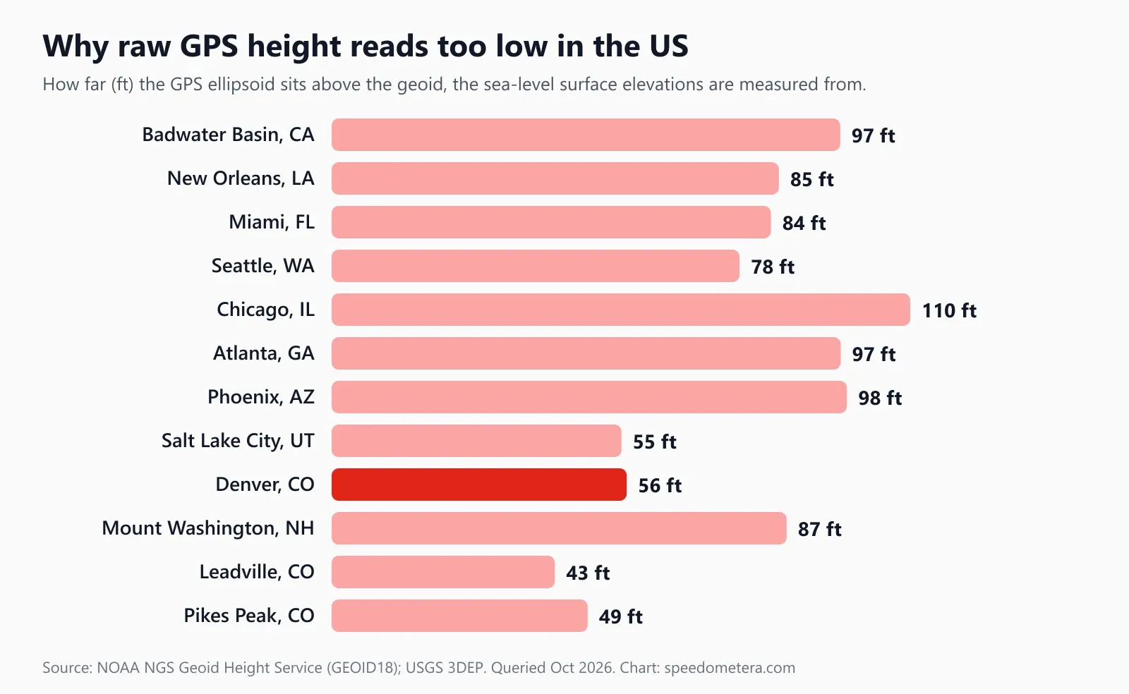
- Uncorrected GPS height is the ellipsoid, which in the lower 48 sits 43–110 ft above sea level (NGS GEOID18)
- Air pressure drops about 1 hPa per 27 ft near sea level, so weather alone can shift a barometric altimeter by 100+ ft
- This tool ignores climbs under 3 m (10 ft) and fixes worse than ±30 m (98 ft) vertical
- US range: Badwater Basin, CA, at about −276 ft to Colorado's 14,000-footers and Alaska's peaks
On this page
- How to use the Altitude: What Is My Elevation?
- Elevation finder: what is my elevation right now?
- How accurate is GPS altitude on a phone?
- Why is my GPS altitude different from the map elevation?
- Barometric altimeter vs GPS altitude: which is more accurate?
- What is the elevation of my city? US examples
- How can I get a more accurate elevation reading?
- Unit conversions for altitude: feet, meters and miles
- Frequently asked questions
How to use the Altitude: What Is My Elevation?
- 1Get a clear view of the skyKeep the phone in your hand or pocket; the page keeps tracking while it stays open.
- 2Tap Start and allow locationYour browser asks for location permission once. The first GPS fix usually arrives in 5–30 seconds.
- 3Pick your unitChoose km/h, mph, knots or m/s. Your choice is remembered on this device.
- 4Read your altitudeThe altitude panel shows GPS height above sea level in feet (mph) or meters, its vertical accuracy, and the lowest, highest and total climb this session.
- 5Stop or resetTap Stop to pause, Reset to clear the trip. Nothing is stored or sent anywhere.
Works in any modern phone browser. Back to the speedometer ↑
What is my elevation? Tap Start on the GPS altimeter above, allow location access, and stand somewhere with open sky: within a few seconds the GPS altitude panel shows your height above sea level in feet (meters outside the US), how accurate that height is, and the lowest point, highest point and total climb since you started. It runs in the browser on iPhone, Android and laptops with GPS, with no app or account.
This page also explains what the number means. Phone GPS is very good at telling you where you are and noticeably worse at telling you how high you are, and the height it measures is not quite the sea-level elevation printed on maps. Below you’ll find measured US examples, the official accuracy figures and the two biggest sources of disagreement, so you can judge any altitude reading, ours included.
Key terms. Elevation: height of the ground above mean sea level. Altitude: height of an object (you, a drone, an aircraft) above a reference. Ellipsoid (WGS84): the smooth mathematical Earth that GPS works in. Geoid: NOAA’s model of global mean sea level, the surface that “defines zero elevation”. Geoid height (N): distance from ellipsoid to geoid. Orthometric height (NAVD 88): official US elevation above the geoid. Vertical accuracy: the ± figure your device reports at 95% confidence.
Elevation finder: what is my elevation right now?
Open the page outside, tap Start, allow location, and read the big number in the GPS altitude panel once the vertical accuracy settles. The first fix is usually the least accurate, so give it 30 to 60 seconds. This elevation finder reads your altitude live from your own phone’s GPS, so “my altitude” updates as you climb or descend; it does not look up a map for a typed address, and your location never leaves the device.
- Go outside or to a window. GPS signals are weak and blocked by roofs and concrete. A sidewalk with open sky beats a parking garage every time.
- Tap Start and allow location. On iPhone, make sure Safari has Precise Location on (Settings, Privacy & Security, Location Services). On Android, Chrome needs location permission and the phone’s location set to high accuracy.
- Hold still for the first fix. The phone needs at least four satellites for a 3D position; height is the last part to settle.
- Read your altitude. The panel shows GPS height above sea level in feet (when the speed unit is mph) or meters, its vertical accuracy, and the lowest, highest and total climb this session. “Vertical accuracy ±33 ft” means the device is 95% confident the true height is within 33 ft of the reading.
- Walk, hike or drive. The panel keeps updating. Below it, the standard speedometer shows your speed, distance and trip time, so the same page works as a hiking altimeter and a walking speed tracker.
How the climb counter works, in plain numbers: the tool only adds a change to “Climb” once it is at least 3 m (10 ft) from the last counted height, so a stationary phone jittering by a few feet doesn’t invent phantom climbing. Any fix whose vertical accuracy is worse than ±30 m (98 ft) is ignored for lowest, highest and climb, so one bad reading under a bridge can’t set a false record. If your device doesn’t report vertical accuracy at all, the panel says “not reported by this device” and every fix is used.
Get the steadiest number
Wait until the ± figure stops shrinking, then note the reading. Averaging three readings a minute apart cuts random noise. Keep the screen on: most browsers pause GPS when the page is in the background.
How accurate is GPS altitude on a phone?
Under open sky, expect a phone’s GPS height to be good to roughly ±26 to ±43 ft (95%), about 1.6 times worse than its horizontal position. Near tall buildings, in deep valleys or under heavy tree cover it can be off by 100 ft or more.
The official numbers come from the US government’s GPS Standard Positioning Service Performance Standard (5th edition, April 2020). Table 3.8-3 commits to a global average position accuracy of 8 m horizontal and 13 m vertical, 95% of the time, and a worst-site accuracy of 15 m horizontal and 33 m vertical. Vertical is the weak axis for a simple geometric reason: every satellite you can see is above you, none below, so the receiver can triangulate sideways far better than up and down.
| Accuracy figure (95%) | Horizontal | Vertical | Vertical ÷ horizontal | Source |
|---|---|---|---|---|
| GPS standard, global average | 8 m (26 ft) | 13 m (43 ft) | 1.6× | SPS Performance Standard 2020, Table 3.8-3 |
| GPS standard, worst site | 15 m (49 ft) | 33 m (108 ft) | 2.2× | SPS Performance Standard 2020, Table 3.8-3 |
| Modern receiver, benign conditions (analysis) | 6.4 m (21 ft) | 11.9 m (39 ft) | 1.9× | SPS Performance Standard 2020, Appendix B |
| Smartphone under open sky | 4.9 m (16 ft) | not published; ~8 m (26 ft) at 1.6× | estimate | GPS.gov accuracy page |
| This tool’s cut-off for stats | – | 30 m (98 ft) | – | src/lib/altitude.ts |
Two caveats on that table. First, the smartphone vertical figure is our estimate, scaling GPS.gov’s 16 ft horizontal value by the standard’s 1.6 ratio; GPS.gov does not publish a vertical smartphone number. Second, you will often see “vertical is about 1.5× horizontal” quoted as a rule of thumb; the primary standard actually gives 1.6× on average and 2.2× at the worst site, so we use those figures. The upper end of our ±26–43 ft range is simply the standard’s 13 m global average.
The ± number in the panel comes straight from your device through the W3C Geolocation API, whose altitudeAccuracy is defined in meters at the 95% confidence level. A reading of 5,240 ft ±40 ft therefore means “very likely between 5,200 and 5,280 ft”, not “exactly 5,240”.
What makes GPS height worse, per GPS.gov: signal blockage by buildings, bridges and trees; indoor or underground use; and multipath, where signals bounce off walls before reaching you. Rarer causes include jamming, major solar storms and satellite maintenance. Practically, a city street lined with high-rises is the worst case for altitude, and an open ridge is the best.
Why is my GPS altitude different from the map elevation?
Because GPS measures height above a smooth ellipsoid, maps measure height above sea level (the geoid), and in the continental US the two surfaces are 43 to 110 ft apart. Add normal GPS noise and a 100 ft disagreement with a trail sign is common.
The W3C Geolocation API, which every browser altimeter uses, defines altitude as “the height of the position, specified in meters above the WGS84 ellipsoid”. An ellipsoid is a perfectly smooth, slightly squashed sphere. Real sea level is lumpy: NOAA describes the geoid as “a model of global mean sea level that is used to measure precise surface elevations”, bulging where gravity is stronger. US elevations on USGS maps and NGS benchmarks are orthometric heights in NAVD 88, measured from that geoid.
The conversion is simple:
Elevation above sea level (H) = GPS ellipsoid height (h) − geoid height (N)
NOAA’s National Geodetic Survey publishes N for any US point through its Geoid Height Service, whose stated purpose is converting a GNSS ellipsoid height into the official NAVD 88 height. We queried it (model GEOID18) and the USGS Elevation Point Query Service for twelve US places on 25 October 2026:
| Place (lat, lon) | Elevation, USGS (ft / m) | Geoid height N, GEOID18 (m / ft) | Raw ellipsoid height h (ft) | Raw GPS reads low by (ft) |
|---|---|---|---|---|
| Badwater Basin, CA (36.2297, −116.7676) | −276 ft / −84 m | −29.5 m / −97 ft | −373 ft | 97 ft |
| New Orleans, LA, downtown (29.9511, −90.0715) | 1 ft / 0 m | −26.0 m / −85 ft | −84 ft | 85 ft |
| Miami, FL, downtown (25.7743, −80.1937) | 7 ft / 2 m | −25.5 m / −84 ft | −77 ft | 84 ft |
| Seattle, WA, downtown (47.6062, −122.3321) | 172 ft / 52 m | −23.7 m / −78 ft | 94 ft | 78 ft |
| Chicago, IL, Loop (41.8781, −87.6298) | 593 ft / 181 m | −33.6 m / −110 ft | 483 ft | 110 ft |
| Atlanta, GA, downtown (33.749, −84.388) | 1,050 ft / 320 m | −29.6 m / −97 ft | 953 ft | 97 ft |
| Phoenix, AZ, downtown (33.4484, −112.074) | 1,088 ft / 332 m | −29.9 m / −98 ft | 990 ft | 98 ft |
| Salt Lake City, UT (40.7608, −111.891) | 4,264 ft / 1,300 m | −16.8 m / −55 ft | 4,208 ft | 55 ft |
| Denver, CO, State Capitol (39.7393, −104.9848) | 5,276 ft / 1,608 m | −17.1 m / −56 ft | 5,220 ft | 56 ft |
| Mount Washington, NH (44.2706, −71.3033) | 6,274 ft / 1,912 m | −26.4 m / −87 ft | 6,188 ft | 87 ft |
| Leadville, CO (39.2508, −106.2925) | 10,156 ft / 3,095 m | −13.0 m / −43 ft | 10,113 ft | 43 ft |
| Pikes Peak, CO (38.8405, −105.0442) | 14,108 ft / 4,300 m | −14.9 m / −49 ft | 14,059 ft | 49 ft |
Elevations are for the exact coordinates shown, rounded to the foot; a city’s “official” elevation may refer to a different spot. Feet use the exact 1 ft = 0.3048 m.
Three things stand out. Every value of N in the lower 48 is negative, so an uncorrected GPS height always reads too low here, never too high. The error is largest around the Great Lakes and the Southeast (Chicago, 110 ft) and smallest in the Colorado Rockies (Leadville, 43 ft), where the mountains’ extra mass lifts the geoid. And at the coast it produces the classic puzzle of a phone showing −80 ft on a Miami beach.
Whether your phone shows ellipsoid or sea-level height depends on the device and browser: the web standard says ellipsoid, but some platforms pass along a height already corrected to sea level. The quick test: stand beside something with a known elevation (a USGS summit, an NGS benchmark disk, a beach at high tide) and compare. If the reading is low by roughly the N value in the table nearest you, your device reports ellipsoid height; add the difference back mentally.
Barometric altimeter vs GPS altitude: which is more accurate?
A barometric altimeter is better for measuring climbs and descents; GPS is better for absolute height when you can’t calibrate. The best hiking watches and many phones combine both.
A barometric altimeter doesn’t measure height at all. It measures air pressure and converts it to altitude using a standard atmosphere. That makes it extremely sensitive (a few feet of climb is visible), but anything else that changes pressure also changes the reading, and weather does exactly that. Using NASA Glenn’s standard-atmosphere model for the troposphere, we computed how pressure falls with height and how many feet one hectopascal (hPa) represents:
| Altitude (ft) | Altitude (m) | Standard pressure (hPa) | Pressure (inHg) | % of sea-level pressure | Height change per 1 hPa (ft) |
|---|---|---|---|---|---|
| 0 | 0 | 1,014 | 29.94 | 100% | 27 |
| 1,000 | 305 | 978 | 28.88 | 96% | 28 |
| 5,280 | 1,609 | 835 | 24.66 | 82% | 32 |
| 8,000 | 2,438 | 754 | 22.25 | 74% | 35 |
| 10,000 | 3,048 | 698 | 20.60 | 69% | 37 |
| 14,000 | 4,267 | 596 | 17.61 | 59% | 42 |
| 30,000 | 9,144 | 302 | 8.91 | 30% | 73 |
NASA’s curve fit gives 1,014 hPa at sea level, a hair above the usual 1,013.25 hPa standard; the shape of the curve is what matters here.
The right-hand column is the barometer’s weakness. Near sea level, a pressure change of just 1 hPa reads as 27 ft of altitude. A weather front can move pressure by several hPa in a day, so an uncalibrated barometric altimeter left on a desk can “climb” or “descend” 100 ft or more overnight without moving. That’s why pilots reset their altimeters to the local pressure setting before landing, and why hiking watches ask you to calibrate at the trailhead.
| GPS altitude (this tool) | Barometric altimeter | |
|---|---|---|
| What it measures | Distance to satellites | Air pressure |
| Absolute accuracy | About ±26–43 ft (95%), open sky | Good only after calibration at a known height |
| Short-term precision | Noisy, jumps by several feet | Very smooth, resolves a few feet |
| Drift over hours | None | Drifts with weather, ~27 ft per hPa at sea level |
| Works indoors | Poorly | Yes |
| Needs | Sky view | Calibration |
Our recommendation: use GPS altitude to answer “what is my elevation right now?” when you have no reference, and treat a GPS total climb as a reasonable estimate rather than an exact figure. The 3 m deadband already filters most jitter, but on a long, gentle hike GPS can still under- or over-count compared with a calibrated barometer.
What is the elevation of my city? US examples
US elevations run from about −276 ft at Badwater Basin in Death Valley to over 14,000 ft on Colorado’s highest summits, and higher still in Alaska. Where you live sets how thin the air is and how far GPS height may disagree with the map.
From the table above, a few landmarks worth knowing:
- Lowest: Badwater Basin, California, about −276 ft at the coordinates we queried, below sea level. A phone reporting raw ellipsoid height there would show roughly −373 ft.
- Coast: New Orleans and Miami sit within a few feet of sea level. New Orleans downtown measured about 1 ft at our query point.
- Mile High City: the Colorado State Capitol in Denver measured 5,276 ft, within 4 ft of the 5,280 ft in a mile.
- High towns: Leadville, Colorado, about 10,156 ft, is a high-altitude town where air pressure is about 69% of sea level.
- Summits you can drive to: Pikes Peak, about 14,108 ft at our query point, and Mount Washington, New Hampshire, about 6,274 ft, both have summit roads, which makes them good places to test a phone altimeter against a known height.
At 8,000 ft, standard air pressure is about 74% of the sea-level value; at 14,000 ft it’s 59%. Each breath carries proportionally less oxygen than at sea level. If you feel headache, nausea or unusual breathlessness at altitude, descend and seek medical advice.
If you fly, remember that the cabin isn’t the plane: a jet cruising around 30,000 ft (see how fast planes fly) flies in air at about 30% of sea-level pressure, while the cabin is pressurized to a much lower equivalent altitude. Phone GPS altitude in a window seat shows the aircraft’s height, if it gets a fix at all.
How can I get a more accurate elevation reading?
Give the phone open sky and time, average several readings, and correct for the geoid if your device reports ellipsoid height. Those three steps are the difference between a rough first fix and a reading you can quote.
- Open sky beats everything. Move away from tall buildings, cliffs and dense trees. On a city block, an open park or plaza gives the receiver far more sky than a street lined with high-rises.
- Wait for the ± to settle. The first fix after you tap Start is the roughest. Watch the vertical accuracy shrink, then read.
- Average. Take three readings a minute or two apart and average them; GPS errors are partly random, so averaging helps.
- Correct for the geoid. If you compared with a known point and found your device reports ellipsoid height, add the N value for your region (43–110 ft in the lower 48, from the table) to get sea-level elevation.
- Use a known benchmark when it matters. For anything official (flood insurance, construction, surveying), GPS on a phone is not enough. Use a surveyed NGS benchmark, a licensed surveyor, or USGS 3DEP elevation data for your exact coordinates.
- Don’t trust altitude while moving fast. In a car, a train or on a plane, readings lag and jump. Check speed instead with the online speedometer, and compare it with your dashboard on the GPS vs car speedometer page.
Unit conversions for altitude: feet, meters and miles
One foot is exactly 0.3048 m, so multiply meters by 3.2808 to get feet. The panel switches automatically: feet when the speed unit is mph, meters with km/h.
| Meters | Feet | Typical example |
|---|---|---|
| 3 m | 10 ft | This tool’s climb deadband |
| 13 m | 43 ft | GPS standard vertical accuracy, 95% |
| 30 m | 98 ft | This tool’s cut-off for bad fixes |
| 1,000 m | 3,281 ft | A long day hike’s total climb |
| 1,609 m | 5,280 ft | One mile, Denver’s nickname |
| 2,438 m | 8,000 ft | Air pressure about 74% of sea level |
| 4,267 m | 14,000 ft | A Colorado “fourteener” |
| 9,144 m | 30,000 ft | Typical airliner cruise level |
If you’re also converting speeds on a trip, the speed converter handles mph, km/h, knots and m/s, and the compass gives you heading alongside altitude.
For information only
GPS altitude is an estimate that depends on your device, signal and sky view; it can be off by 100 ft or more in cities, canyons and indoors. Don’t rely on it for aviation, flood-zone, surveying or safety-critical decisions. Never handle your phone while driving: mount it hands-free or let a passenger read it.
FAQ
Frequently asked questions
How do I find my current elevation?
Open this page outdoors, tap Start and allow location. Within about 30 seconds the GPS altitude panel shows your elevation in feet, with a vertical accuracy such as ±30 ft. For a benchmark-quality number, look up your coordinates on a USGS or NGS map instead.
How accurate is GPS altitude on a phone?
Roughly 26–43 ft under open sky by our estimate, and worse near buildings and trees. The US GPS standard commits to 13 m (43 ft) vertical error 95% of the time versus 8 m horizontal, so height is roughly 1.6 times less accurate than position.
Why does my GPS altitude differ from the map elevation?
Mostly because GPS measures height above a smooth ellipsoid, while maps use sea level (the geoid). In the lower 48 states the two differ by 43 to 110 ft. Add normal GPS vertical error of 26–43 ft and a 100 ft disagreement is not unusual.
Is altitude the same as elevation?
Nearly. Elevation usually means the height of the ground above sea level; altitude means the height of an object, such as you, a drone or an aircraft. Standing on the ground the two are the same number, for example 5,276 ft at Denver's State Capitol.
Is a barometric altimeter more accurate than GPS?
For changes in height, yes: a barometer resolves a few feet of climb. For absolute height it drifts with the weather, about 27 ft per 1 hPa of pressure change at sea level, so it must be reset at a known elevation. GPS height does not drift with weather but is noisier second to second.
Does phone altitude work without cell service?
Yes. GPS satellites broadcast free signals your phone receives directly, so altitude works in airplane mode or in a canyon with no bars. The first fix can take noticeably longer, because the phone cannot download satellite data over the network.
How much thinner is the air at high elevation?
At 8,000 ft (2,438 m) standard air pressure is about 74% of sea level, and at 14,000 ft about 59%, per NASA's standard-atmosphere model. Each breath carries proportionally less oxygen, which is why visitors to Leadville, Colorado, at about 10,156 ft, feel it.
What is the elevation of Denver, the Mile High City?
About 5,276 ft (1,608 m) at the Colorado State Capitol according to the USGS elevation service, close to the 5,280 ft of one mile. Raw ellipsoid GPS height there would read about 56 ft lower, near 5,220 ft, unless the device corrects for the geoid.
How do I see elevation on my iPhone or Android?
Open this page in Safari or Chrome, tap Start and allow precise location; the altitude panel works on both. Readings refresh whenever the device delivers a new fix. If vertical accuracy says not reported, the browser gave no estimate, so treat the number as ±50 ft or more.
Does my iPhone have an altimeter?
Yes, in effect. Apple's built-in Compass app shows your elevation at the bottom of the screen, next to your bearing and coordinates, though Apple notes elevation may not be available in every country or region. In a browser, the altimeter on this page uses your phone's GPS altitude instead.
Is 2,000 ft considered high altitude?
No. Altitude illness becomes common much higher up: the CDC Yellow Book reports acute mountain sickness in about 25% of visitors sleeping above 8,000 ft (about 2,450 m) in Colorado. At 2,000 ft (610 m) most people notice no effect at all on breathing or sleep.
Can Google Maps show my current elevation?
Not as a live number for your own position. Google Maps Help describes a Terrain layer that shows elevation contours, and walking and cycling routes show the climb, but it documents no altitude readout for where you stand. Tap Start on the altimeter above to see your GPS elevation in feet or meters.
10 Sources
- Google Maps Help: Use layers to find places, traffic, terrain, biking & transit
- GPS.gov (US government): GPS accuracy, smartphones typically within 4.9 m (16 ft) under open sky
- GPS Standard Positioning Service Performance Standard, 5th Edition (April 2020), Table 3.8-3: 8 m horizontal / 13 m vertical, 95%
- W3C Geolocation API: altitude in meters above the WGS84 ellipsoid; altitudeAccuracy at 95% confidence
- NOAA National Geodetic Survey: Geoid Height Service API (GEOID18), converting GNSS ellipsoid heights to NAVD 88
- NOAA Ocean Service: What is the geoid?
- USGS Elevation Point Query Service (3DEP elevation data), queried 25 Oct 2026
- NASA Glenn Research Center: Earth atmosphere model (standard-atmosphere pressure vs altitude)
- CDC Yellow Book: High-altitude travel and altitude illness (AMS in 25% of visitors sleeping above 8,000 ft in Colorado)
- Apple iPhone User Guide: Use the compass on iPhone (bearings, coordinates and elevation)
Last updated October 25, 2026 by Izhar Ahmad Danish. Found an error? Tell us.